


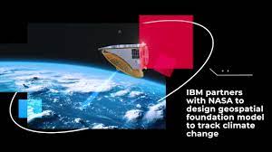
Geospatial Model: NASA Forms Association with IBM’s AI To Discover Climate Data
Geospatial Model: The Geospatial Model is a collaborative project between NASA and IBM that utilizes Artificial Intelligence (AI) and Machine Learning to analyze environmental data and transform satellite observations into detailed maps. It aims to identify key areas prone to natural disasters and landscape formations. IBM’s Geospatial AI model, known as ‘watsonx.ai,’ is being utilized to generate valuable information for businesses and projects. By converting satellite data into customized maps, this model helps evaluate climate-related risks, plan infrastructure, inform decision-making, and protect the environment. Through AI-based visualizations, the Geospatial Model enhances disaster management and supports future projects. The partnership between NASA and IBM demonstrates the use of advanced technology to address the Earth’s climate crisis and pave the way for a sustainable future.
Geospatial Model:
What is Geospatial Model?

The Geospatial Foundation Model is a specialized technology that helps analyze and understand data related to maps and geographic information. It uses advanced techniques to detect patterns and trends in location-based data, allowing us to predict and understand various environmental conditions. By leveraging this model, scientists and researchers can gather valuable insights about our planet’s landscapes, weather patterns, and other geographical features. This information is crucial for addressing environmental challenges, planning infrastructure, and making informed decisions to protect our planet.
Why Geospatial Model is Significant ?

The Geospatial Model collaboration between NASA and IBM is in the news due to its significance in addressing the Earth’s climate crisis. This joint effort to harness advanced technology, such as Artificial Intelligence (AI) and Machine Learning, to analyze environmental data and transform satellite observations into detailed maps has garnered attention. The model aims to identify key areas prone to natural disasters, such as fires and floods, and understand landscape formations. By leveraging IBM’s Geospatial AI model, the partnership seeks to generate valuable information for businesses and projects. The project’s focus on climate change research and analysis has attracted media coverage, highlighting the importance of using innovative approaches to address environmental challenges.
Conclusion
In conclusion, the collaboration between NASA and IBM to develop the Geospatial Model represents a significant step forward in addressing the Earth’s climate crisis. By leveraging the power of Artificial Intelligence (AI) and Machine Learning, this innovative technology allows for the analysis of environmental data and the transformation of satellite observations into detailed maps. This partnership aims to provide valuable insights into climate-related risks, assist in disaster management, and guide future strategies for climate change mitigation. With the Geospatial Model’s ability to detect patterns and analyze geographic information, it opens new avenues for understanding our planet’s landscapes and environmental changes. This joint effort underscores the importance of utilizing advanced technologies to better comprehend and tackle the challenges of our changing climate, paving the way for a more sustainable future.